

For generations farmers have worked to preserve their local environment. Today, there are government regulations to ensure that the environment continues to be protected. As part of this, in New Zealand, farmers are now required by law to manage nutrient loss to water.
You can’t manage what you don’t measure.
Unfortunately, to date, there has been no practical way to actually measure nutrient leaching losses from farms. So farmers are required to estimate what their nutrient losses might be, using models. And very critical decisions, costing in some cases many thousands of dollars, are made based on estimates alone.
GroundTruth system
- Directly measures leaching loss without the use of models.
- Accurate. Designed to achieve equal or greater accuracy in relation to leading university and CRI techniques.
- Affordable. Minimises capital investment to allow funding from many sources.
- Simple to use. Does not impede cultivation or grazing.
- Versatile. Can measure Nitrogen, Phosphorus (leaching only), chemical residues, microbial losses…
Uses
- Collect data from situations not yet well supported by models, for model development purposes.
- Research plot trials.
- Research farmlet trials.
- On-farm model validation.
The GroundTruth system is not a replacement for models. Models estimate loss from an entire property, while GroundTruth measures actual loss but only from a single location. Models are useful, but cannot be trusted (especially for regulatory purposes) if there is no way of verifying their results. The GroundTruth system gives a practical way to verify the results of models.
An ideal use of GroundTruth would be, for example, where computer models estimate particularly high leaching loss in a certain situation (e.g. a particular crop, or a particular irrigation system), the estimated losses are high enough to trigger regulatory penalties, and the farmers concerned are not convinced the numbers are accurate. The GroundTruth System can be used to measure actual leaching losses underneath that crop to determine whether the modelled numbers were accurate, and provide the data needed to improve the model if problems are identified.
A more ideal use would be to monitor leaching losses from field trials and farmlet trials in research settings, to inform model development and ensure accuracy before those models are ever used in a regulatory context.
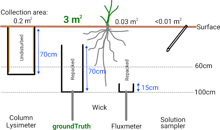
How it works
- Lysimeter. Collects all drainage from a 10m long strip in a paddock. Can be positioned anywhere in a paddock. Unaffected by cultivation - farm staff can ignore it entirely. Averages variation in loss along that strip. Equivalent size to 15 research lysimeters, 95 fluxmeters or 300 suction cups / electronic probes.
- Autosampler. Measures drainage volume, and gives an estimate of nutrient concentration in real time. Collects a drainage sample for chemical analysis. Solar powered, long range radio.
- Chemical analysis. Water samples are sent periodically for chemical analysis in a laboratory. The system does not rely on novel sensors, nutrients are measured accurately using well-established methods.
- Data management. Calculates nutrient leaching losses. Presents all data on a website in real time. Remotely monitors all devices. Alerts user when samples need collecting.

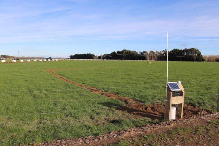
Installed system
The below image is of a system immediately after installation, before recovery of the pasture. The line of disturbed soil running from the autosampler straight into the paddock is a pipeline. The lysimeter is at the end of this pipeline, running left-to-right in this image approximately 30m from the fenceline. It is barely visible as a line of disturbed soil. After pasture recovery the lysimeter is completely invisible.
For more information
This system is already installed in multiple locations around the South Island of New Zealand. A peer-reviewed paper describing the system has been published in the Journal of New Zealand Grasslands, and the system is being actively used for research by major research providers in both Canterbury and Southland.
More information on the GroundTruth system may be found on our blog.
A demonstration system is installed at Lincoln. To view the data from this system in our client data portal, click here or on the “My Data” link at the top right of this site. Use the username “demo” and password “demo”.
Contact us for questions and quotes.